
‘Fortune and glory, kid. Fortune and glory.’
Indiana Jones, Temple of Doom
According to Strava, as of February 2023, I’ve completed 1,977 individual runs. Jesus. Pre-2014 I was on Runkeeper (remember that? It’s now the MySpace of running apps) so the total figure since I started recording mileage is probably nearer 23 hundred million or something. Point is, that’s a lot.
I’ve met a few people over the years who’ve told me they tried running but gave up as they found it boring. Unlike team sports, or even going to the Gym, running can be a pretty lonely place. Basically, I buy the ‘boring’ argument. In the same conversation I’ll also get asked how do I counter the tediousness of running anywhere between 25 minutes and a few hours. ‘Variety is the Spice of Life’ I’ll say, while my colleague looks at me like I’ve got a turd on my head.
Lots of different routes is what I’m trying to say. Hardly brain surgery or trying to work out today’s Wordle is it? Although personally I’m a daily player of Lewdle instead. I once got ’Minge’ in one. Anyway, if I just ran the same route every day I’d be bored shitless. More bored than watching all of the Fast and the Furious franchise back to back. Actually, even one of the fuckers.
Over the years I’ve planned and tried routes that were great, some that were blatantly a bad idea half way round, and others that were put together months in advance with military precision using Google Maps and no social life.
Some have become real regulars, like old friends, ‘Go To’ routes when I need to get out of a running rut or I can’t be arsed to plan ahead that far. I’ve therefore decided to do a series on the best (lucky fucking you) starting with my absolute favourite child. This one I’ve called ‘Four Villages and the Sea’, because basically I couldn’t think of anything cleverer to call it. And when you upload the GPS, it sadly doesn’t look like anything rude or funny.
The great thing about this route is that I can do 3 slightly different versions of it dependent on how arsed I can be. It’s either 10 mile (can’t be arsed) 11.5 mile (slightly more arsed) 13.1 mile (beast mode). Seeing as the Half Marathon Beast Mode covers all three, we’ll concentrate on that.
The first part of the run is pretty urban, and I don’t mean the Stormzy grime version of it. This is middle class suburbia at its dullest. I think the most exciting thing that ever happens on this part is during May-July, when the Seagulls nest and completely lose their shit when you run into their ‘area.’ I’ve never taken a direct hit from one of these flying rats, but only because I have the reflexes of a Puma.
Next we’re into Earsdon. Briefly. A once small farming community, now just a collection of nice old stone houses. When we were house hunting, my wife and I went to look at a ‘Cottage’ here. That sounds romantic, but you literally couldn’t swing a cat in it. I know because I took ours with me to test it.
Now we’re heading into some countryside. Well, we’re surrounded by fields for about a mile. It’s a long straight road into our next stop which is Holywell. Holywell is famous for its Dene, called Holywell Dene you sarcy bastards. The Dene is lovely but not somewhere I run a lot. As it’s a Dene it has steep sides to get in and out of it. I’m classing those as Hills. It’s also a quagmire of mud 8 months of the year and you don’t want to see my wife angry when I pop back with half a field attached to my soles.
Holywell is then absorbed by the larger Seaton Deleval, home of the infamous Deleval family. More on them in a bit. It’s all gone a bit ‘Urban’ again and Deleval is a bit rougher, but it’s hardly the home of the Mexican Cartel.
We’re now heading into Village No 3 and probably the most interesting of all – New Hartley. Historically a Mining community, in 1862 the biggest Pit Disaster in the World occurred here, when 204 men and children perished after becoming trapped underground. I grew up in a neighbouring Pit Village with all the men two generations above me old pitmen, so knew the details of this story before I could even count to 10.
You would never know as I run through this quiet village now. All signs of the Pit are long gone, other than a small memorial garden at the site of the Shaft. There was a bit of a local stink a few years ago, when the council sold off the land above the exact spot where the Miners were trapped to a Housing Developer. Common sense prevailed. Did it shite. Money talked, and now that field is another identikit New Build Estate. I’d make old pits National Monuments, but I would say that.

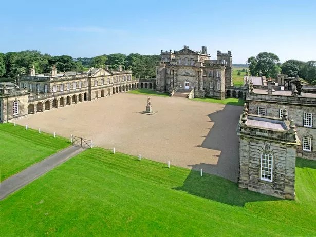
We leave New Hartley but we’re still on the History trail. Next stop – Seaton Deleval Hall – once home of the Deleval family. Hedonistic party animals of the 17th and 18th Century, if the stories are to be believed. The National Trust own the Hall now, where I’m sure they tell visiting children the more vanilla stories, and not the ones that involve hookers, donkeys, and coke.
This is also my favourite part of the run and the bit I try to savour. We’re still surrounded by fields, but as we’re going downhill (woo-hoo!) towards the coast so for the first time the sea is also now in view. On a clear day, I can also glance to the left and see the Cheviots. Honestly, play me some Elgar and I’ll be balling my eyes out.
We hit the coast and sadly Ladies and Gents what comes down must go up. I’m into Village 4 – Seaton Sluice – and now it’s a straight run South hogging the shoreline to get back to Whitley Bay, concrete jungle where dreams are made from. And. unfortunately, the first mile of it is all uphill.
I’ve mentioned my ‘love’ of hills in past posts. However, I don’t mind this climb too much. One reason, I’ve done it a lot, so I’m convinced good old muscle memory – if you believe in such mumbo-jumbo – means this hill in particular is less of a ball ache. The other is the view. This climb runs right alongside the coastline, Collywell Bay to be exact, so take a look to the left and you’ve got nothing but the sight and sound of the North Sea. In the Summer, on a hot day, the breeze that comes off the sea here can be a refreshing and natural cool down as you slog your way up. In the Winter, it can be an absolute howling bastard.
At the very top of the hill you reach The Deleval Arms, a tempting place to pop in to at this point after the hill has you wankered. Two random facts about this pub. The first is, I used to be able to see it from my living room window even though I lived about 3 and half miles away as the crow flies, such is the height of the hill it’s on plus the fact I backed on to green belt. The 2nd is that there is a big fuck off boulder right in front of it. The Blue Stone of Old Hartley to give it it’s proper name.
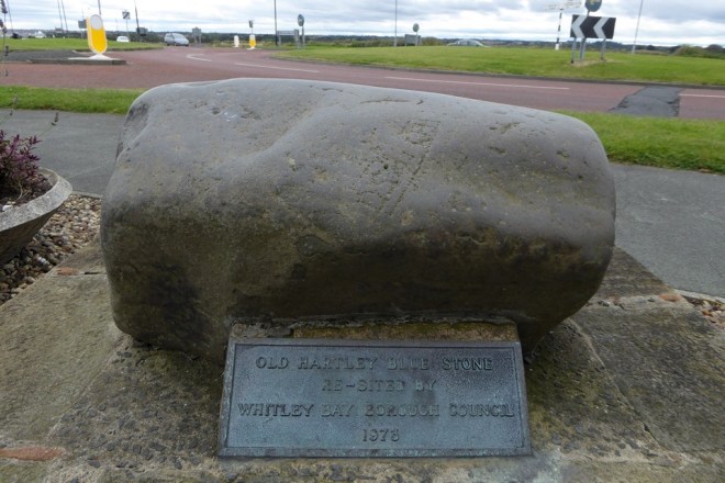
The reckon this stone used to the boundary stone for the original Saxon Village that sat here. The villages at the time thought touching it kept you clear of the Plague. Rumors that during the Pandemic people were out giving it a daily stroke are unconfirmed. The other legend around the stone is that renowned local 17th Century ‘Strongman’ William Carr is the only man who has been able to lift it. Think of a Vitamin C deprived Geoff Capes. Random fact – my wife met Geoff Capes as a kid in the 80s. She has no amusing anecdote to go with it sadly, other than a picture I’m not allowed to publish.
One last fact about the stone in the picture above – it isn’t actually the real Blue Stone. It’s a replica. Too many pissed up wannabe Brock Lesnars keep trying to lift it in the Dutch courage/sense lost haze of 12 pints. The original, and keep this to yourself, is in the pub car park hidden amongst other stones. Shhh.
After that climb the good news is we’re into our last couple of miles and the rest of the way is flat as a fart. We’ve dropped off road onto the coastal path and we’re about to pass the Jam in Whitley Bay’s Doughtnut – St. Mary’s Lighthouse. It’s iconic, and everyone in the town is obsessed with it. You’ll see Lighhouses everywhere. In Gardens, on Mantlepieces, Stain Glass Windows. When I did a bit of self employed work, I even added it to my Invoice Header. You’ll also see lots of messages on social media from some of the more mature residents of the Bay wringing every week that it needs a wash/lick of paint. IT’S IN THE NORTH FUCKING SEA. It gets lashed by dirty waves and shit on by those aforementioned flying rats every day man. You’d need to clean it every morning. Jesus wept.
People mostly view the Lighthouse from the town to the South, but I always think the view coming in over the cliffs from the North is better. It’s where it looks like it’s in the middle of nowhere, as a Lighthouse should be, plus if you time it right in the morning the Sun rises just behind it.

As soon as the coastal path ends, the town of Whitely Bay starts. From here, it’s a simple run along the path by the main coastal road until I drop onto the start of the Lower Prom. I’m now literally at Sea Level and follow the Prom all the way to it’s end at Watt’s Slope, around 3/4 of a Mile. Although, depending on the weather and how fit I am, this can feel like a horrible 5k where I just want to die. For any Parkrunners amongst you, this is also a section of the Whitely Bay Parkrun. Again, if the weather is great then this is a beautiful stretch to run. If it’s shit, then this will be a world of cold, wet pain. I finish at the end of the Prom and we’re done. Half Marathon. Piece of piss.
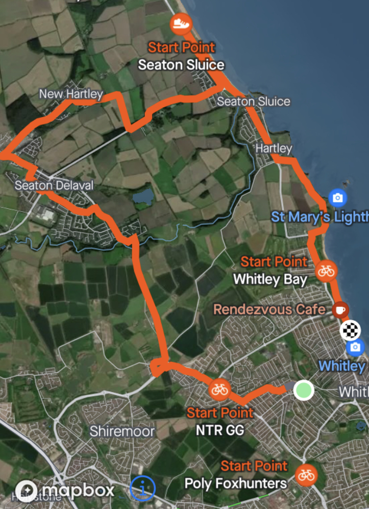
And there you go. You’ve learnt shit loads there. Win a Pub Quiz with some of that. One thing you will notice from the map above – there is a gap between where I start and where I finish. Why? Because I really can’t be arsed to run uphill back to home. I’ve just run a Half Marathon man, what else do you want?
